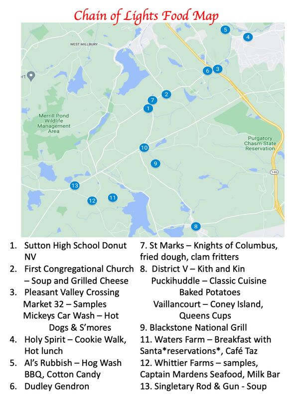
Location The Town of Sutton is located in central Massachusetts (Worcester County) in an area known as the Blackstone Valley. The Town is located along Route 146 and is 8 miles south of Worcester, 30 miles north of Providence, and 46 miles southwest of Boston. From the Mass Pike, take exit 10A to Route 146 South to Boston Road. Parking is available at the Sutton High School Trolley Hub.
|
Route 1
1. Trolley Hub -- Sutton High School - Switch Trolley Routes Here 2. First Congregational Church (R/H/P/L) 307 Boston Rd. 3. Pleasant Valley Crossing (P/H/R/L) 29 Galaxy Pass Unibank - Sutton North ( Market 32 Mickey's Car Wash 4. Holy Spirit Episcopal Church (R/P/H/L) 3 Pleasant Street 5. Al's Rubbish and Container Service (P/H/L) 77 Providence Road 6. Dudley Gendron (R/P/H/L) 156 Boston Road 7. St Mark's Church (R/P/H/L) 356 Boston Road |
Route 2
1. Trolley Hub -- Sutton High School - Switch trolley routes here 8..Manchaug Village District V House (R/P/H/L) 356 Manchaug Rd Puckihuddle (R/P/H/L) 6 Main Street Manchaug Mills (R/P/L/H) 9 Main Street Vaillancourt Folk Art (R/P/H) 9 Main Street 9. Blackstone National Golf Club (R/P/H/L) 227 Putnam Hill Road 10. Sutton Police Station (R/P/H) 489 Central Turnpike |
Route 3
1. Trolley Hub -- Sutton High School - Switch trolley routes here 11. Waters Farm (R/P/H/L) 53 Waters Road 12. Whittier Farms (R/P/H/L) 90 Douglas Road 13. Singletary Rod & Gun Club 300 Sutton Ave, Oxford |